HATALMAS VÁLASZTÉK
Több mint 4 millió angol nyelvű könyv kitűnő áron.

| ISBN | 9780008653002 |
|---|---|
| Szerző | Collins |
| Kiadó | Collins |
| Nyelv | english |
| Kötés | Folded |
| A kiadás éve | 2024 |
| Oldalak száma | 2 |
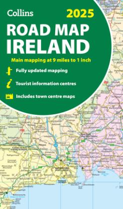
Full-color map of Ireland at 9 miles to 1 inch (1:570,240), with clear, detailed road network and counties and new administrative areas shown in color. This double-sided map covers the whole of Ireland, and is ideal for reference or route planning.
This map of Ireland shows the road network in detail. It is ideal for business users, with coloring of local council areas, but it is also perfect for tourists as a route planning map.
Main features include:
Area of coverage
Covers the whole of the Republic of Ireland and Northern Ireland.

Több mint 4 millió angol nyelvű könyv kitűnő áron.

25 500 Ft vagy nagyobb rendelés esetén a szállítás ingyenes

A könyvek árait igyekszünk a földhöz közel tartani és mindig a kiadó által ajánlott ár alatt.

Számunkra a legfontosabb az Ön elégedettsége. Könyveket árulunk, mert szeretjük őket. Nem transznacionális óriások vagyunk, hanem becsületes cseh cég. Ezenfelül a kitűnő könyveket saját blogunkban véleményezzük.

Megkaptuk a "Megbízható Bolt" címet az arukereso.hu portálon. Az értékeléseket megtekintheti itt